Regional potential analysis for rainwater utilization in Campinas, Brazil

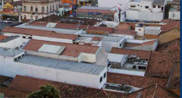
High degree of sealed soil in the center of Piracicaba, in the Campinas region.

The south-east of Brazil, particularly São Paulo and its surrounding area, is marked by strong industrial and demographic growth. Therefore, environmental problems such as water pollution and scarcity of resources are increasing. For almost ten years scientists of the Fraunhofer IGB have been maintaining project partnerships with academic institutions and the relevant authorities of the Campinas region in the State of São Paulo to jointly develop innovative and sustainable water management solutions. Here, a special mention should be given to the Methodist University Piracicaba (UNIMEP). The exploitation of rainwater offers great potential. On the one hand, the precipitation intensity and the large areas of sealed soil within the cities often cause localized flooding. On the other hand, the demand for drinking water has strongly increased over the past years, resulting in temporary supply bottlenecks. A helpful alternative to current municipal water management could be provided by means of customized storage, processing and utilization of the harvested rainwater. To assess the potential rainwater yield and demand at regional level the Fraunhofer IGB in co-operation with the IGVT of the University of Stuttgart are utilizing and progressing spatial planning methods which build on geographical information systems (GIS). Their German partner is the Institute of Geography of Tübingen University which is providing planning details for the conceptual water and wastewater management.

Combination of geographic satellite data with regional precipitation maps

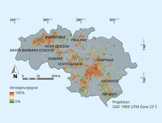
Sealed soil areas in the cities based on Landsat satellite data.
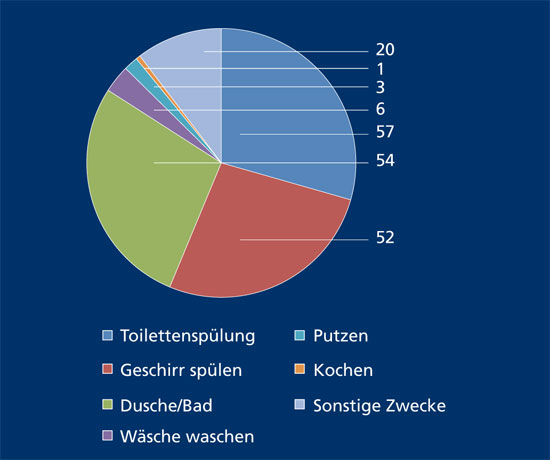
Domestic water consumption in l / cap / d for South Brazil; total consumption 173 l / cap / d.
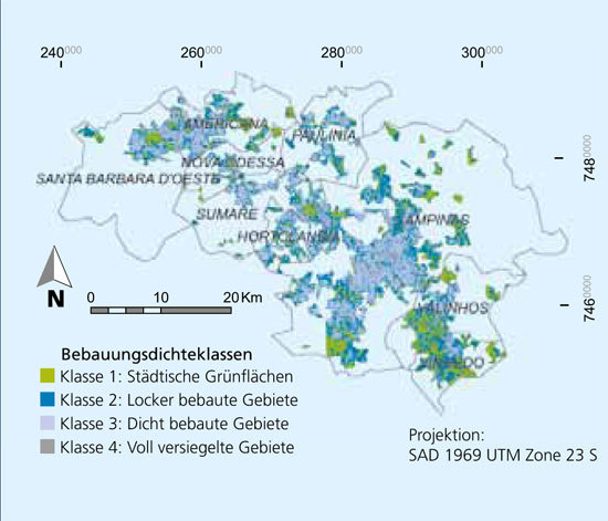
Classes of different development densities as the basis for the rainwater requirements assessment.

At regional level satellite data with medium spatial resolution, such as can be obtained from the Landsat system, provide a solid basis for the derivation of various planning parameters for rainwater utilization. For the Campinas region the degree of sealed soil in settlement areas was calculated pixel-based with the help of the software application Impervious Surface Analyst of Würzburg University [1]. Through combination with regional precipitation maps it was possible to estimate the potential yield and the spatially distributed amount of rainwater available annually. In addition, the sealed soil map provides a basis for assessing various requirement values which could be compared with local yield values. As a first step we have estimated the population density spatially distributed over the individual regions based on the assumption that the density of development correlates with the population density [2]. For certain domestic uses, such as toilet flushes per capita, it was possible to include figures from local statistics to determine requirements. Demand for watering public green spaces and gardens as well as for other uses (washing the car, external cleaning) varies depending on the development density. It was possible to determine four different requirement classes for irrigation by means of regression analysis using some high-resolution satellite data (Worldview 2).

Potential yield and result

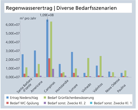
Comparison of rainwater yield and various requirement scenarios for municipalities in Campinas.

As a result it is now possible to compare the potential yield with various requirement scenarios for rainwater utilization for individual municipalities. The diagram below shows that as an annual total amount sufficient rainwater is available in the cities of the Campinas region to meet various requirements. Demand for the watering green areas is estimated as very high as fallow land is also included in the evaluation. Further detailed planning is necessary for implementation purposes.

Perspective

The GIS-supported approach provides the possibility to evaluate the yield and demand situation relating to individual areas. In terms of the local level this means that, for instance, semidecentralized rainwater utilization units can be determined. The suitability of the basic data plays a decisive role here, with satellite data ensuring independence from national authorities. The method is based on standard software systems. The aim is to support regional planners and the planning of municipal water management operations.

References

[1] Esch, T.; Himmler, V.; Schorcht, G.; Thiel, M.; Wehrmann, T.; Bachofer, F.; Conrad, C.; Schmidt, M.; Dech, S. (2009) Large-area assessment of impervious surface based on integrated analysis of single-date Landsat-7 images and geospatial vector data, Remote Sensing of Environment, 113(8): 1678-1690

[2] Steinnocher, K.; Petrini, F.; Tötzer, T.; Wechselbaum, J. (2005) Räumliche Disaggregation von sozio-ökonomischen Daten, AGIT-Symposium XVII, Salzburg, Juli 05